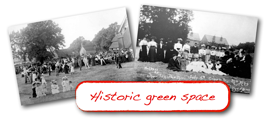
With the generous support of local ‘star’ historian Joan Ham, we’re reproducing her insightful article (first published in the Three Heralds magazine) which outlines the historic importance of the Glebe Field to Storrington. As Joan writes: “It is our last peaceful bit of green which it would be a great pity to lose.”
THE CHURCH MEADOW
by Joan Ham
Lying between West Street and School Lane, and E-W between the Church Street houses and the old Storrington Common (now bounded by Monastery Lane) was a green meadow. This was shown on the old parish map of 1788 divided into several parts by hedges, the larger parts belonging to W.Goble. A smaller western part and a house, the property of T.Skinner and a house and narrow strip along today’s School Lane belonging to E. Slater. Next to this, Goble had another small plot and messuage, and between this and the churchyard was Batcock’s property. The West Street edge along the road was divided into plots with buildings shown on some of them. One of Goble’s fields extended right out to the street between two groups of houses. North of the church between Thomas Batcock’s property and Church Street, the Rev. Mr Copley had property with buildings and a coppice.
The tithe map of 1841, which, however, has everything squared off, even ponds, should be regarded as a tax document rather than a geographically accurate map as it’s purpose is to show properties liable for the tithe, payable to the incumbent. The Town Meadow as it was then known, shows the whole 10 acres 1r 5p without internal hedges as the property of the Rev. Henry Warren with a small area next to the churchyard as “Warren’s plot”, 1acre 3p.
Storrington’s commons, properly called manor wastes, belonged to the Lord of the Manor, and were not enclosed until 1851 and shows the Rev. Henry Warren still owning the 10a 1r 5p of the Town Meadow and the little 1a 3p near the churchyard, previously the property of Goble.

In 1877 a poster was published “to the Surveyors of Storrington Sussex,” signed by the Rev. James Beck of Storrington, Clerk in Holy Orders, giving notice to the churchwardens to assemble the inhabitants in the Vestry, “to s_ubmit to them my wish to divert a certain footpath across a portion of a field called or known as “Dixon’s Field” …“. In accordance with this, the Rector, churchwardens and surveyors called a Vestry meeting for 22 February 1877 to consider the matter.
Two footpaths entered the field from West Street, one near the present Village Hall (not then built ) and the other about half-way along West Street, possibly the site of today’s Rectory road. They converged to a single path which then ran to the NW corner of the churchyard. The Rev. James Beck of Parham, where there was no rectory house, had bought a plot of land with a cottage called “the Bartons” on Church Street, north of the church and shown in the 1788 map as belonging to the Rev. Mr Copley. He had pulled down the old cottage and was building an imposing Victorian house with a carriage drive from Church Street and gardens backing on to “Dixon’s Field”. The proposed diversion would have moved the footpath away from his garden and would have squared off the western boundary neatly.
The Dixon for whom the fields was known was Dr Dixon who had established a pill-making enterprise in Batcock’s cottage next to the churchyard in School Lane. Elizabeth Batcock was the pill-maker, reputed to be still working at the age of 100, when a peal of bells was rung to celebrate her great age.
The churchyard was rapidly filling up, and more space was needed, so Batcock sold his cottage and plot of land to accommodate more burials. This is the part below the bank, west of the original churchyard, where interment of ashes takes place, and the pump marks the old cottage garden site. When even this enlargement began to fill up, another area of the church meadow was enclosed to the north.
The newest and third Rectory was built in 1934 on a part of the church meadow behind Mr Beck’s house. Rectory Road was laid for access from West Street, which took in more of the field, when a close of houses was built later on the eastern side of Rectory Road.
Mrs Ravenscroft owned property along West Street east of Rectory Road and a plot of land with £500 had been given some years before to build a village hall, but as the money was not sufficient for the purpose, the land lay vacant. In 1947 Mrs Ravenscroft took out a Tree Preservation Order on the row of limes and sycamores which bordered the field above the retaining wall.
A letter from the Church Commissioners dated 23 January 1953 stated:
“The land you described as “Church Meadow” is not owned by the Church Commisssioners but appears from the files at this office to form part of the glebe land belonging to the benefice of Storrington.
If this is so, then the land would vest in the incumbent of the benefice concerned, who has power to sell subject to certain consents.
This benefice, however, is at present vacant and any proposal to sell would rest with the Bishop…
The local authority has not yet written to this office about the acquisition of “Church Meadow” for housing.”
There was a strange position at the time, as the Rev. W.R. Bassett-Smith of Sullington and the Rev.W. Frostick of Storrington had both retired at the same time. The Bishop was patron of Sullington and Keble College of Storrington but they agreed to the plurality with alternate rights of appointment. The Queen had to sign an Order in Council, agreeing to this, but she was touring Australia and nothing could be done until her return, so the Rev. George Mackenzie was priest-in-charge of Storrington with a dispensation to live at the Rectory.

The western side of the church meadow lost more of its space when the Glebe Surgery was built to replace the old bungalow in Amberley Road which had served the local doctors for some years and had become inadequate for the growing population of the village. Now, even that modern surgery is overwhelmed and needs enlarging or replacing.
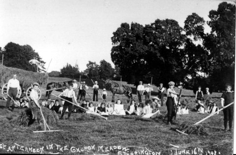
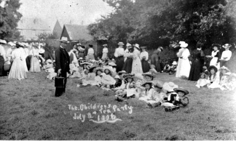
The church meadow, shown on maps variously as “Mr Warren’s piece”, “Cartwright’s” or the name of the current curate, was used by the Rev. Arthur Faithfull as a hayfield where children were allowed to play. Other events were al fresco tea parties given to the children by local worthies such as Mrs King’s Jubilee Tea Party. During WWII children from the village school crossed the field to the Village Hall, keeping them safe away from road traffic where Mrs Waller, the headmaster’s wife had organised a canteen to give them hot dinners. Today it is a popular dog-walking route much enjoyed by people escaping the continuous roar of large vehicles and cars through the village.
It is our last peaceful bit of green which it would be a great pity to lose.
Reproduced with kind permission of the author/Three Heralds

